Truth in advertising: This is a blog, and it is ironic. I leave it as an exercise to the reader to choose an appropriate definition of irony, provided that it is fully consistent with the contents of this blog.
Thursday, November 13, 2008
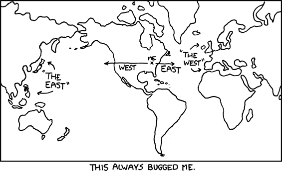
East v. West. Two XKCDs in a row; I know. I'm lazy.
I instantly identified with this, although it took me a few minutes to realize why. (Easy answer follows the images)
Why? "The East" and "The West" were named before anyone knew of the various continents in the actual Western hemisphere. Thanks Europe. That's just great.
Of course, it takes major cajones for anyone to publish a map that splits the continent of Asia - and the most populous country in the world - right down the middle just so the U.S. can be in the center of the map.
Good point, reader. I had forgotten about how super-cohesive Asia is, and about all the bonding and love the Asian countries share. It's like 10,000 years of zero conflict over there, and a cartoonist at XKCD chose to split that geography in half to make a joke. OUTRAGEOUS.
2 comments:
Of course, it takes major cajones for anyone to publish a map that splits the continent of Asia - and the most populous country in the world - right down the middle just so the U.S. can be in the center of the map.
Good point, reader. I had forgotten about how super-cohesive Asia is, and about all the bonding and love the Asian countries share. It's like 10,000 years of zero conflict over there, and a cartoonist at XKCD chose to split that geography in half to make a joke. OUTRAGEOUS.
Post a Comment